
|
GABON: Highlights | Slideshow | Wildlife | Gorillas | Rainforest | Deforestation |
|
Pictures of Gabon
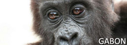
All images are the property of Rhett A. Butler / mongabay.com, copyright 2006. Contact me regarding use and reproduction.In May - June 2006 I visited the Central African country of Gabon, a place known for its biodiverse rainforests. These are my pictures. More information on Gabon is available below the galleries.  Highlights [40 pictures] Other categories
More on Gabon Gabon: Environmental Profile Gabon Deforestation Rates and Related Forestry Figures Roads tied to bushmeat hunting in Africa Gabon sets aside 10 percent of country as protected parks Freshwater fish of Gabon Further information coming soon GPS coordinates/readings for Loango National Park Tassi, St. Anne, Point St. Catherine, Evengue, Iguela, Akaka elevation: 3 feet, 02'04'408 south, 9'26'609 east Elevation: 60 feet, 02'02'513 south, 9'24'836 east Elevation: 17 feet, 01'54'717 south, 9'14'590 east Elevation: -4 feet, 02'13'596 south, 9'40'772 east Latitude / Longitude Recent news on Gabon:
|


what's new | rainforests | tropical fish | for kids | search | about | copyright & use | contact |
Copyright Rhett Butler 1994-2012 Pictures were taken by Rhett A. Butler, copyright 1996-2009. While these photos are the property of mongabay.com, it may be permissible to use them for non-commercial purposes (like powerpoint presentations and school projects), provided that the images are not altered in any form. Please read this for more details. If you are interested in using an image in a publication please contact me. Mongabay.com is a free resource. |